Angkor Wat: The Largest Religious Monument Ever Built and the City That Vanished
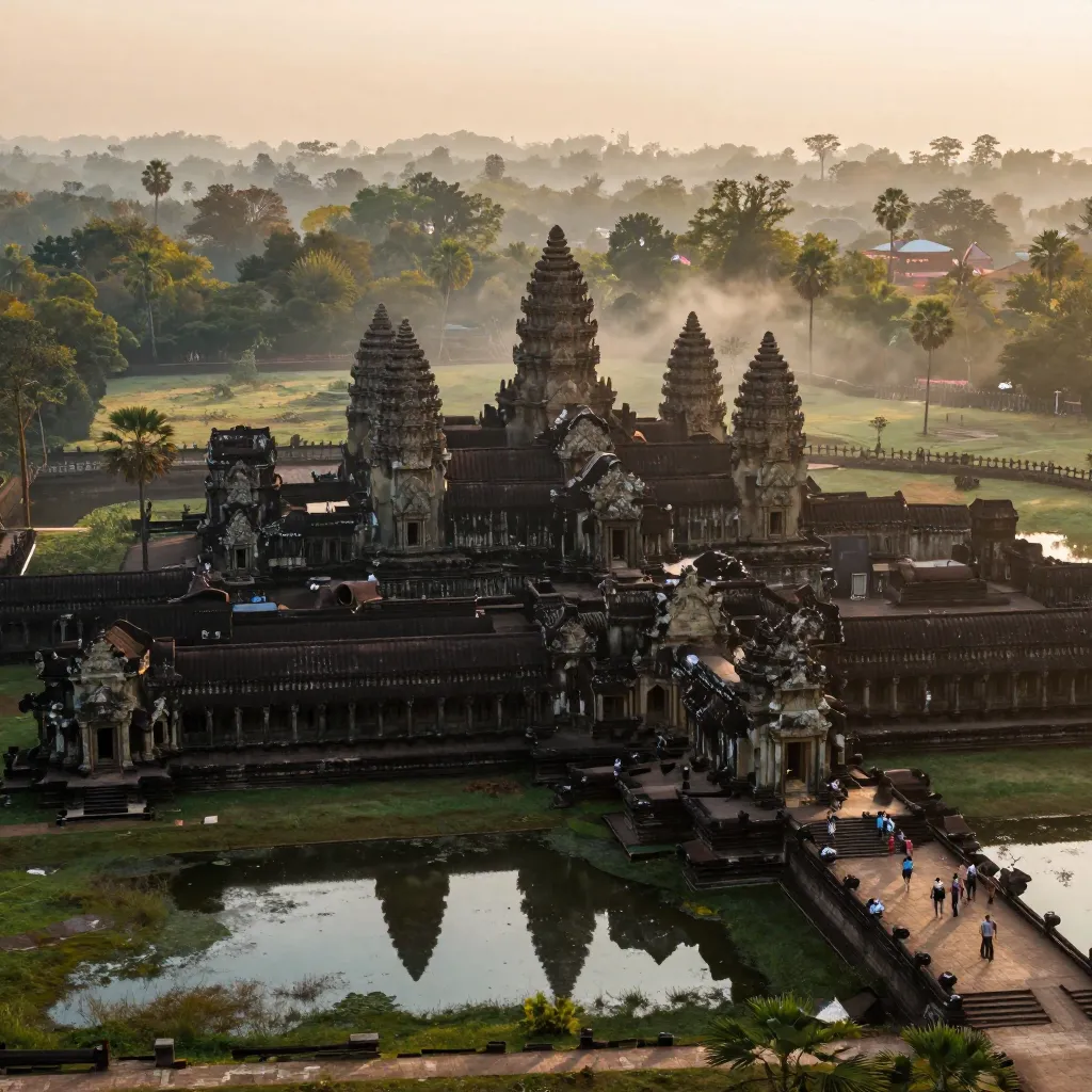
Angkor Wat at dawn, the largest religious monument ever constructed, reflects in its ancient moat
In the dense tropical jungle of northwestern Cambodia, surrounded by moats filled with lotus flowers and encircled by walls longer than a kilometer on each side, stands the largest religious monument ever built by human hands. Angkor Wat — whose name means “City of Temples” in Khmer — covers approximately 162.6 hectares (401 acres), an area so vast that it dwarfs every cathedral, mosque, and temple on Earth. Its five iconic towers, arranged in a quincunx pattern representing the sacred peaks of Mount Meru, rise to a height of 65 meters above the surrounding plain. Its walls are covered with over 12,000 square meters of bas-relief carvings depicting scenes from Hindu mythology, historical battles, and the daily life of the Khmer Empire at its zenith. It was built in the first half of the twelfth century by King Suryavarman II, one of the most ambitious rulers in Southeast Asian history, as a temple dedicated to the Hindu god Vishnu and, many scholars believe, as the king’s own funerary monument. And yet, within three centuries of its construction, the great city that surrounded it — a metropolis that may have been the largest urban complex in the pre-industrial world — was swallowed by the jungle, abandoned by its people, and largely forgotten by the outside world.
The story of Angkor Wat is the story of human ambition pushed to its absolute limits — and then pulled back by the same forces of nature and history that have swallowed every great civilization. It is a story of engineering genius, religious transformation, imperial overreach, and the haunting beauty of ruins reclaimed by the tropical forest. Modern LIDAR surveys have revealed that the Angkor urban complex was far larger than anyone imagined — a low-density megacity stretching over 1,000 square kilometers, larger than modern Los Angeles, crisscrossed by an elaborate hydraulic system of canals, reservoirs, and moats that managed water for over 750,000 inhabitants. The mystery of Angkor is not only how it was built, but why it was abandoned — and what its rise and fall tell us about the precariousness of even the most magnificent human achievements.
Suryavarman II came to power around 1113 CE after a violent succession struggle that may have included the assassination of his predecessor. He was a king of extraordinary ambition, both in war and in architecture. During his reign, which lasted until approximately 1145 or 1150 CE, he waged military campaigns across Southeast Asia, extending Khmer influence from the Vietnamese coast to the Malay Peninsula, and launched the construction of the most ambitious building project the region had ever seen. Angkor Wat was not merely a temple — it was a cosmological diagram in stone, a representation of the Hindu universe built on a scale so colossal that it required the labor of tens of thousands of workers, artisans, and engineers over a period of approximately 37 years.
The temple’s design is a masterpiece of symbolic architecture. The central five towers represent the five peaks of Mount Meru, the sacred mountain at the center of the Hindu cosmos, home of the gods. The surrounding moat, measuring 1,500 by 1,300 meters — nearly a square mile of water — represents the cosmic ocean. The three concentric galleries represent the three levels of the universe: the underworld, the earth, and the heavens. The entire complex is oriented to the west, an unusual direction for Khmer temples (which typically face east, toward the rising sun), which has led many scholars to suggest that Angkor Wat was designed as Suryavarman’s tomb, since west is the direction associated with death in Hindu cosmology. The precision of the construction is extraordinary: the walls are aligned to the cardinal directions with an accuracy of less than one degree, and the dimensions of the complex encode mathematical relationships that reflect sophisticated astronomical and calendrical knowledge.
Angkor Wat was constructed from an estimated 5 to 10 million sandstone blocks, some weighing up to 1.5 tons each. The stone was quarried from the Kulen Hills, approximately 40 kilometers to the northeast, and transported to the construction site by a system of canals and possibly rollers and elephants. The total volume of stone used is comparable to the Great Pyramid of Giza. Unlike the Egyptian pyramids, however, virtually every surface of Angkor Wat was carved — walls, doorways, columns, roofs, and galleries are covered with intricate reliefs depicting deities, dancers, warriors, and scenes from Hindu epics. The most famous relief, the “Churning of the Ocean of Milk,” stretches for nearly 50 meters along one of the gallery walls and depicts 88 devas (gods) and 92 asuras (demons) pulling on the serpent Vasuki to churn the cosmic ocean and produce the elixir of immortality. The level of detail is staggering: each figure has individualized facial features, jewelry, and clothing, and the entire composition is choreographed with a sense of movement and energy that feels almost cinematic.
Angkor Wat did not stand alone. It was the centerpiece of a vast urban complex known as Angkor, the capital of the Khmer Empire from the ninth to the fifteenth centuries CE. The true scale of this city remained hidden until the twenty-first century, when LIDAR (Light Detection and Ranging) surveys — airborne laser scanning that can penetrate the jungle canopy — revealed the outlines of a metropolis of staggering proportions. The Greater Angkor Project, a collaborative research effort involving the University of Sydney, the École française d’Extrême-Orient (EFEO), and Cambodian authorities, used LIDAR to map the landscape beneath the jungle and discovered that the Angkor urban complex covered approximately 1,000 square kilometers — making it the largest known pre-industrial urban settlement in the world.
The key to this vast city’s existence was water. The Angkor region sits in a seasonal tropical climate with a dramatic monsoon cycle: months of heavy rain followed by months of near-drought. The Khmer engineers solved this problem with an elaborate hydraulic system of barays (massive artificial reservoirs), canals, moats, and embankments that captured monsoon runoff and released it during the dry season, ensuring year-round irrigation for rice cultivation. The largest baray, the West Baray, measured approximately 8 kilometers by 2.2 kilometers and held an estimated 50 million cubic meters of water — one of the largest artificial bodies of water ever created in the ancient world. This hydraulic infrastructure allowed the Khmer to produce rice surpluses that supported an enormous urban population, fed the armies that built the empire, and sustained the labor force that constructed the temples.
The LIDAR surveys conducted at Angkor beginning in 2012 revolutionized our understanding of the site. By firing millions of laser pulses from aircraft and measuring the time it takes for the light to bounce back, researchers were able to create detailed three-dimensional maps of the ground surface beneath the dense tropical canopy. The results were astonishing: beneath the jungle lay the remains of entire neighborhoods, roads, canals, ponds, and temples that had been invisible to ground-based researchers. The LIDAR data revealed that Angkor was a low-density megacity, a sprawling urban landscape of villages, rice paddies, and temple complexes interconnected by a vast network of roads and waterways — fundamentally different from the dense, walled cities of medieval Europe but comparable in population and far greater in area. The surveys also revealed previously unknown temples, including one — Mahendraparvata — hidden beneath the jungle on the Kulen Hills, predating Angkor itself.
One of the most fascinating aspects of Angkor Wat is the way its religious identity shifted over time, leaving visible traces in the architecture and carvings. Suryavarman II built the temple as a Vaishnavite Hindu monument dedicated to Vishnu, and the earliest carvings reflect Hindu iconography: Vishnu reclining on the serpent Ananta, the battle of Kurukshetra from the Mahabharata, and the Churning of the Ocean of Milk from the Ramayana. But by the late thirteenth century, under the influence of Theravada Buddhism spreading from Sri Lanka and the Mon kingdoms, the temple was gradually converted to Buddhist use. New carvings were added depicting the Buddha and scenes from Buddhist scripture. Existing Hindu carvings were sometimes modified — Vishnu figures were subtly re-carved as the Buddha. The transition is visible in the stone itself, a palimpsest of religious change that makes Angkor Wat a unique document of spiritual transformation. The temple remains an active Buddhist worship site today, visited by monks and pilgrims who continue a tradition of devotion stretching back over 800 years.
By the fifteenth century, the great city of Angkor was in terminal decline. The precise causes of the abandonment remain debated, but a convergence of factors — environmental, political, and economic — appears to have been responsible. In 1431, the Siamese (Thai) kingdom of Ayutthaya attacked and sacked Angkor, dealing a devastating blow to the already weakened Khmer state. The Khmer court moved the capital south to Phnom Penh, closer to the sea and to trade routes that had become increasingly important as maritime commerce supplanted the overland networks that had sustained Angkor’s economy.
But the Siamese invasion was likely the final blow, not the root cause. Environmental factors played a critical role. Studies of sediment cores from the Tonle Sap lake and the moats of Angkor have revealed evidence of prolonged droughts in the fourteenth and fifteenth centuries, punctuated by periods of intense monsoon flooding. The Khmer hydraulic system, designed to manage water in a predictable monsoon cycle, may have been unable to cope with these extremes. During droughts, the reservoirs ran dry; during floods, the canals overflowed and the barays may have breached their embankments. The damage to the water management infrastructure would have cascaded through the entire system: without reliable irrigation, rice production fell; without surplus rice, the urban population could not be fed; without a fed population, the labor force needed to maintain the hydraulic system could not be sustained. The result was a positive feedback loop of decline — each failure accelerating the next.
Of all the temples of Angkor, none captures the drama of nature reclaiming human achievement more vividly than Ta Prohm, built by Jayavarman VII and deliberately left in a state of partial ruin by modern conservators. Massive silk-cotton trees and strangler figs grow directly from the temple’s walls and rooftops, their roots pouring over doorways and crushing stone blocks with slow, irresistible force. The effect is hauntingly beautiful — a visual metaphor for the entire Angkor story. When the French École française d’Extrême-Orient (EFEO) began conservation work at Angkor in the early twentieth century, they discovered that the jungle had done extraordinary damage: tree roots had pried stones apart, monsoon rains had eroded carvings, and decades of accumulated vegetation had destabilized foundations. The decision to leave Ta Prohm largely unrestored was made to preserve this powerful image of nature and architecture locked in a slow-motion struggle.
The French naturalist Henri Mouhot is often credited with “discovering” Angkor Wat in 1860, but this is a myth. The temple was never truly lost — local Cambodian communities had maintained it as an active Buddhist pilgrimage site for centuries. What Mouhot did was bring Angkor to Western attention through his vivid published descriptions, which inspired a wave of French colonial exploration and, eventually, the establishment of the EFEO conservation program in 1898. Today, Angkor Wat is a UNESCO World Heritage Site (inscribed in 1992) and one of the most visited archaeological sites in the world, attracting over 2.5 million tourists annually. Conservation is an ongoing challenge: the sheer number of visitors causes physical wear on the stone, groundwater extraction threatens the stability of foundations, looting of carvings remains a problem, and the tropical climate accelerates deterioration. Multiple international teams — from France, Japan, China, Germany, and others — are engaged in continuous restoration work, using everything from traditional stone masonry to laser scanning and 3D modeling to preserve the temple for future generations.
Angkor Wat is a paradox. The empire that built it — the Khmer Empire, the dominant power in Southeast Asia for nearly five centuries — has vanished into history. The hydraulic system that sustained the greatest pre-industrial city on Earth has been dry for centuries, its canals clogged with earth, its reservoirs silted into meadows. The religious traditions that inspired its construction have been superseded, first by Buddhism and then by the secular modernity of the twenty-first century. And yet the temple endures. It stares out from the Cambodian flag, the only national flag in the world to feature a building. It draws millions of visitors who stand in its galleries and gaze at carvings made by hands that have been dust for eight centuries. The Khmer engineers who designed the water system, the stone masons who carved the reliefs, and the kings who commissioned the temples are all gone — but their work remains, a testament to the human compulsion to build something that will outlast the builder. Everything else is commentary on the persistence of stone and the impermanence of empires.
References & Further Reading
Wikipedia: Angkor — The vast urban complex and capital of the Khmer Empire
Britannica: Angkor Wat — Authoritative summary of the temple complex and its historical significance
Wikipedia: Suryavarman II — The Khmer king who commissioned Angkor Wat and expanded the empire
Wikipedia: Henri Mouhot — The French naturalist who brought Angkor Wat to Western attention in 1860
Britannica: Angkor (Historical City) — History of the Khmer capital from its founding to abandonment
📚 Recommended Reading: Angkor and the Khmer Civilization by Michael D. Coe (on Amazon) — As an Amazon Associate, we earn from qualifying purchases.
Editorial note: reconstructions are continuously revised as imaging and inscription studies improve. See our Editorial Policy.